![[Link to www.VanGoghGallery.com]](/images/logoh.jpg) |
Ireland |
![[Link to www.VanGoghGallery.com]](/images/logoh.jpg) |
Ireland |
This page contains information about maps of Ireland, administrative divisions
of Ireland, civil and Catholic parishes of Ireland, and South Ulster.
| |
|
| |
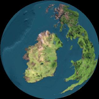
 Here
is a view from 40 kilometers above Ireland published with the kind permission
of The Living Earth®, Inc., dba
Earth Imaging. Living Earth® was formed to produce and manage high-quality,
color-enhanced satellite images of Earth for virtually any application. Their
neat website allows you to view the earth from the sun, the moon, or a space
satellite. Their images are composites of multiple high-resolution satellite
images and are color-enhanced. They use public domain satellite imagery acquired
from the EROS Data Center. By use of their own proprietary process, clouds
are removed from the images. This image is subject to a copyright by The Living
Earth®, and has been reproduced from their website with their permission,
with the understanding that it will be published only with this copyright
notice, and will be used only in this noncommercial family genealogy website.
Any reproduction or downloading of this image requires the permission of The
Living Earth, Inc.
The Home Rule Map of Ireland, published in 1893, which is part of the General Maps section of the American Memory Collection of The Library of Congress, is detailed, zoomable, and fun to use. Several old maps of Ireland are part of this collection, including Baptista Boazio's Irlandiæ c. 1606 = Irlandiæ accurata descriptio.
Several Ireland
Maps are in the Perry-Castañeda
Library Map Collection, which the University of Texas has made part of
its online library. As part of their Guide
to Irish Genealogical Research, RootsWeb has published a guide
to maps. 
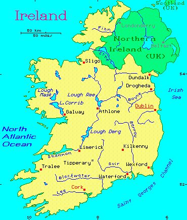
Computer Aided Technologies has published free programmable maps in bmp format. Here is their map of Ireland. County Monaghan, ancestral home of most of the McGoughs, is the arrowhead pointing into Northern Ireland, to the northwest of Dundalk.
Multi Media Mapping offers a good computer map that allows construction of a detailed map of any part of the world. National Geographic's Map Machine will locate even small towns in Ireland on a small scale map. The GEOnet Names Server of the National Imagery and Mapping Agency makes available the latitude and longitude of even small villages in Ireland, such as the village of Aghnamullen.
Ireland's History in Maps provides a birds-eye view of Irish history. Over a period of centuries, the Anglo-Normans conquered Ireland and, during the great wars of Elizabeth I, broke the force of the semi-independent Irish chieftains, "crushed the native population to dust" (to use a favorite phrase of W. E. H. Lecky), and established the complete ascendancy of English law. There was no lack of courage, intelligence or ferocity on the part of the Irish. They were ground down by the superior organization of the English government. W. E. H. Lecky, an English historian who takes an unvarnished look at the cruelties of the English in the subjugation of Ireland, sums up:
"It was probably a misfortune that Ireland never passed, like the rest of Europe, under the subjection of the Romans, who bequeathed, wherever they ruled, the elements of Latin civilization, and also those habits of national organization in which they were pre-eminent." A History of Ireland in the Eighteenth Century, by W. E. H. . Lecky (University of Chicago Press, abridged edition, 1972), page 4.
The Ireland's History in Maps website has extracted the Irish section of the map Insulae Brittanicae from the University of Texas Map Collection. On the same site is an 1808 Map of Ireland. If you are willing to endure a long download, the entire Insulae Brittanicae map shows the places where Roman remains have been found in Great Britain. See also the map of Roman Britain about 410 and the Ecclesiastical Map of the British Isles in the Middle Ages (about 610). For more historical maps of Ireland, go to Maps of Ireland. For a map showing the six provinces of Ireland and their location in relationship to Dal Riada, Strathclyde, and other early kingdoms of Scotland and England, see Post-Roman Celtic Britain —The Island of Britain AD 450–600. Maps of Celtic Ireland are published in connection with an article on Irish Brooches of the Early Medieval Celtic Period by Alisa Petti, part of an exhibition on Celtic Art & Cultures on the website of the University of North Carolina at Chapel Hill. For more maps, go to Maps and Timelines on the same website.
Ancestry.com has published a Regional map of Ireland and Northern Ireland showing the four provinces and regional clan associations about 1500.
A modern detailed highway map of Ireland in PDF format has been published on the Internet by Actov8 Design 2000.
For more maps, look at my Links page under Maps.
To locate McGoughs in Ireland and make the best use of the data in this website, acquiring some good large scale maps and an understanding of the administrative divisions of Ireland will be a great help. In these pages, I often refer to the 1:50 000 Maps of Ireland. There are 89 sheets in the Discovery/Discoverer series of these maps; 71 in the Discovery series are published by the Ordnance Survey of Ireland, and 18 in the Discoverer series by the Ordnance Survey of Northern Ireland. These maps are suitable for locating the Irish places identified on this website. The Discovery series shows place names in both English and Gaelic, while the Discoverer series uses only English. I have some of these maps on cork board with pins showing the various townlands in which McGoughs were located in the seventeenth, eighteenth and nineteenth centuries. The patterns tell a story that is difficult to absorb from mere words. My grandson, also Hugh McGough, who was two years old on August 13, 1999, has created a new game of pulling the pretty colored pins out of the maps, testing the patience of his sometimes irascible grandfather.
In this website, I use the Irish grid references on these maps to describe locations. The grid system breaks the land into one kilometer squares and permits designating a location within a tenth of that distance, 100 meters. The system is a delight to work with in finding places and measuring distances—if you have the right map. The problem is that the grid system is not directly convertible to latitude and longitude and is specific to a series of maps. Reference to the grid is of little or no help to someone who does not have a copy of a map that uses the system. See: Interactive Guide to the National Grid on the Get-a-map website (which covers the UK, including Northern Ireland).
For a good overview, see Administrative Divisions of Ireland. A map of the provinces and counties of Ireland has been published on the website called Mother Bedford's Ulster-Scot Heritage. See also the Map of the Old Irish Provinces and Counties and Counties and Provinces of Ireland (on the Travel Through the Ireland Story ... website). Ann McGeough Harney has published a map of the baronies of county Monaghan. The Ulster Historical Foundation has published a map of the civil parishes of county Monaghan.
The key unit in Irish genealogical research is the townland.
"Townland. This is the smallest administrative division and on average covers about 350 acres It is the most ancient geographical unit in Ireland and the one which researchers struggle to identify when searching for their ancestors. Many townlands share the same name. For example: there are 56 Kilmores and 47 Dromores. County Derry has 1247 townlands grouped into 46 civil parishes. A full list is available in the Valuation Office.
"The townland was named at an early period and often the name was derived from some local physical feature or landmark such as a mountain, bog, forest, a village, or a church. The townland became standardized as the unit of measurement during the seventeenth century surveys. The townland names were originally in Irish Gaelic, but they became modified as a result of English speaking clerks writing the names as they heard them, using the Latin alphabet to approximate Gaelic word sounds.
"The Ordnance Survey completed in 1846 contains maps at the scale of six inches to the mile of each of the 60,462 townlands in Ireland. An index to these was published by Alexander Thom in 1861 and reprinted by the Genealogical Publishing Company in 1981 under the title General Alphabetical Index to the Townlands and Towns, Parishes, and Baronies of Ireland.
"When testifying before the Select Committee on County Cess, Griffith was asked whether the boundary of a townland is the boundary of a parish, are the boundaries in any degree commensurate? He responded:
"'The boundaries of parishes are always boundaries of townlands; that is to say, one townland cannot be contained in two parishes; it sometimes happens that an estate may lie on both sides of the boundary of a parish, and that the townland in each parish is called by the same name, and is considered to be one townland, but in such cases I have always divided the townland, and added the word upper or lower, east or west, to the original name, to serve to distinguish them. As each parish will be separately assessed, it is necessary that no confusion should arise as to the boundaries of any denomination or division belonging to it, consequently in all cases the boundary of a parish must likewise be the boundary of a townland as far as that parish or the county assessment is concerned." From: Administrative Divisions of Ireland on the Fianna Guide to Irish Genealogy.
Townlands are grouped into civil parishes, which are grouped into counties, which are grouped into provinces.
Sharon Oddie Brown, on her website The Silver Bowl, has published a map of the townlands of the civil parish of Aghnamullen, county Monaghan, and several other maps of townlands and parishes in counties Monaghan and Armagh.
A fairly complete set of townland maps has been published for county Tyrone. In my page McGoughs, McGeoughs and McGoughs in County Tyrone, I have created a link to those maps for each of the parishes in which I have found a McGough. For a reader with much patience, and the appropriate Discoverer/Discovery maps, this page could serve as a good tutorial on the relationship of the various administrative divisions of Ireland and the maps.
See also: Irish Townland Maps at FHC. Ann McGeough Harney has published the FHC townland maps for the civil parish of Aghnamullen in county Monaghan. Al Beagan's Genealogy Notes contains county Cavan maps with the LDS sketch maps showing the townlands within each civil parish. Ed Finn has published a map of the townland boundaries in the Catholic parish of Inishkeen, county Monaghan. IreAtlas SEARCH PAGE lists all the townlands in Ireland and may be searched either by townland or by county. Type in the name of a townland and it will show the counties in which a townland of that name appears. Type in the name of a county, and it gives the townlands in that county.
A reference to the map showing the townland boundaries within the Catholic parish of Innishkeen in county Monaghan will help illustrate the differences between the Catholic and civil parishes. On this map, locate the townland of Kilmurry at the northwest tip. Draw a line along the eastern edge of Kilmurry and continue south along the eastern edges of the townlands of Colgagh, Tattyboy, Mullaghunshinagh, Moyles, Drumnanaliv, Muff, Mucker, Kednaminsha, and Coolderry. The townlands named, and the townlands to their west on the map of the Catholic parish, are in the civil parish of Donaghmoyne. They will not be found on a map of the civil parish of Inishkeen, which is only about half as big as the Catholic parish of Inniskeen.
Another example of the disparity between civil and Catholic parishes is found in the twenty-two townlands at the southeast corner of the civil parish of Clontibret. These townlands are in the Catholic parish of Muckno. The townland of Corwillin, according to my maps, is in the civil parish of Aghnamullen, but in the Catholic parish of Tullycorbet. The townlands of Corbrack and Agheralane, to the immediate northeast of Corwillin, are in the Catholic parish of Aughnamullen East, but in the civil parish of Ballybay.
To say that the differences between the civil and Catholic parishes leads to confusion of amateur genealogists, such as myself, is an understatement. Since I published my tables of McGoughs in the Tithe Applotment Books and Griffith's Valuation, which are based on the civil parishes, I have received several email messages from knowledgeable researchers into the McGoughs in Ireland expressing bafflement over why they can't, for example, find in my tables the townland of Mullaghunshinagh (364–7) under the parish of Inishkeen, where they know it is located. The answer is that, while Mullaghunshinagh is in the Catholic parish of Inniskeen, it is in the civil parish of Donaghmoyne and not in the civil parish of Inishkeen. My tables are based on the civil parishes.
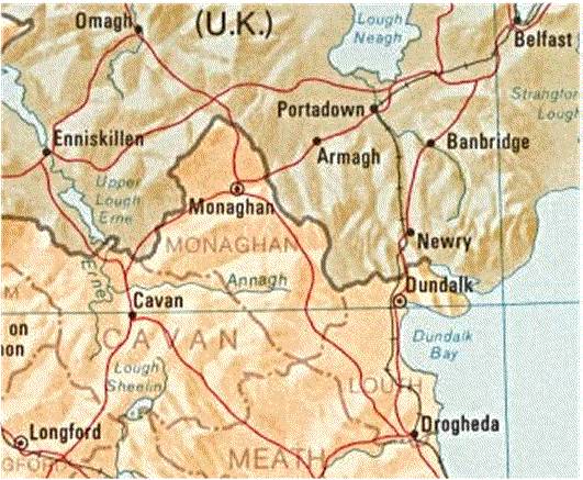
 As
mentioned above, a good topographical
map of Ireland is part of the Perry-Castañeda
Library Map Collection, which the University of Texas has made part of
its online library. This excerpt from that map shows the eastern part of mid
and south Ulster, the original home of most of the McGoughs in Ireland. The
only other significant concentration of McGoughs is in county Mayo in the
province of Connaught, north of Galway on the west coast.
The greatest concentration of McGoughs has been in county Monaghan, roughly in the center of the map. Within county Monaghan, the greatest concentration has been in the part of the civil parish of Aghnamullen that is now the Catholic parish of Aughnamullen West. That parish is just north of the Annagh River as shown on this map, roughly where the letters An in Annagh are located, and the white space to the immediate north.
After Monaghan, the number of McGoughs in relation to the geographic area of a county was greatest in county Louth. There were also a significant number of McGoughs in counties Tyrone, Armagh, and Meath, to which I have devoted separate web pages.
For more on Ireland, see my page of Links.
| Ireland <http://www.magoo.com/hugh/ireland.html> Updated October 16, 2012 |
![[Link to www.VanGoghGallery.com]](/images/potatoesred.jpg) |
Feedback
» Site Search & Directory » © 1999–2012 Hugh McGough » |