![[Link to www.VanGoghGallery.com]](/images/logoh.jpg) |
Territories of Clan Grant in Scotland |
|
Territories of Clan Grant in Scotland |
Two of the six smaller regions of the Highlands, in the north of Scotland, are involved in my brief history of the Grants and the Gordons: Moray Speyside and Cairngorms National Park. Here is a map of Cairngorms National Park. More than half of Scotland’s malt whisky distilleries are situated in Moray Speyside. See: Malt Whisky Trail, including The Glenlivet in Glenlivet and the Glenfiddich Distillery in Dufftown, founded by William Grant in 1887. The Spey River Catchment Interactive Map is helpful and entertaining. See also: Map of the Spey River System and Fishing on the Spey. See also:Speyside Way, a long distance walk on Undiscovered Scotland, which includes a 15 mile (each way) spur from Ballindalloch through Glenlivet to Tomintoul. and a 4 mile spur from Craigellachie to Dufftown. For a map of the fishing areas on the Spey (Google Map Showing all Spey Beats) and good photographs of captured salmon, go to River Spey by Ian Gordon on Speyonline. For a multi-layered map, see: Map of River Spey and Map of Old County Banffshire on Gazetteer for Scotland.
Map Search is an interactive search tool published as part of the Highland Historic Environmental Record by The Highland Council is helpful in exploring historical sites in Badenoch and Strathspey.
The Chiefs of Grant (volume I, part 1) by William Fraser, Edinburgh 1883 (a free eBook). Volume II. Correspondence — Volume III. Charters, part 1 and part 2. Volumes II and III are on the Hathi Digital Trust Library. See also: Clan Grant and Clan Grant of Glenmoriston on The Highland Clans of Scotland: Their History and Traditions by George Eyre-Todd.
Stand Fast Craigellachie, the motto of the Clan Grant, is celebrated in verse as illustrated by the first verse of a poem from the web page of the Clan Grant Society:
Stand Fast Craigellachie
For centuries our fathers slept
within their Chieftain's way ;
Where ospreys plunged and salmon leapt
In the tempestuous Spey.
Their dear-loved homes they viewed with pride
Their peaceful joys to count ;
They rallied to their Chieftain's side
Where blazed the "fiery mount."
So proudly let our glorious chant
Still echo through Strathspey.
"A Grant ! A Grant ! A Grant ! A Grant ! "
Stand fast Craigellachie !
On YouTube, trains of Canadian Pacific Railway roll down the track to the tune of Stand Fast Craigellachie! Craigellachie is a location on the Eagle River in British Columbia, Canada, that is named after the village of Craigellachie on the River Spey in Moray, Scotland. The Last Spike of the Canadian Pacific Railway was driven into the track bed at Craigellachie, British, Columbia, at 9:22 AM on November 7, 1885.
Craigellachie in British Columbia is on Trans-Canada Highway #1, 28 miles west of Revelstoke and 18 miles east of Sicamous.
Craigellachie, BC, is a small community located at the west entrance to Eagle Pass. Craigellachie was the place where Donald Smith drove the symbolic "last spike" in a ceremony marking the completion of the Canadian Pacific Railway, 7 Nov 1885. It was named for a rocky crag in Morayshire, Scotland, where Smith grew up. The battle cry "stand fast" is associated with the Morayshire crag. Smith and fellow Scotsman George Stephen felt the need of this battle cry during the building of the scandal-and financial-plagued railway. Craigellachie was designated a national historic site in 1971. —Craigellachie on Historica Canada.
Donald Alexander Smith (1820–1914), who drove the last spike, was born at Forres, Scotland on August 6, 1820. He was the second son of Alexander Smith (1786–1847) and his wife Barbara Stuart*, daughter of Donald Stuart (b.c.1740) of Leanchoil, Upper Strathspey, and Janet T. Grant (1743– ),descended from Murdoch Stewart, 2nd Duke of Albany. His father, whose family had lived at Archiestown Cottage as crofters at Knockando, became a saddler at Forres after trying his hand at farming and soldiering. He was a first cousin of George Stephen. —Donald Smith, 1st Baron Strathcona and Mount Royal on Wikipedia. Scotland, Select Births and Baptisms, 1564–1950 on ancestry.com lists the birth date of Donald Alexander Smith as August 5, 1820, and his baptism date as October 4, 1820. The place of baptism was Forres, Moray, Scotland. His mother's name is listed as Barbara Stewart. Donald Alexander Smith married Isabella Sophia (Grant) Hardisty on March 9, 1853, , who was born on May 4, 1825, in Rupert River District, Canada, and died on November 12, 1913 at 28 Grosvenor Square, London. Isabella had previously been nominally (and perhaps invalidly) married in 1851 to James Grant, who was born in canada in about 1820. <Lynch/Kearney/Inwood/Phelan Family Tree> and <Ryk Brown's Tree - July 2010> on ancestry.com Public Member Trees.
*Both Barbara Stuart and Alexander Smith belonged to Clan Grant whose members were concentrated in the Spey Valley which runs parallel to the Moray Firth and had long been famous as one of the prime centres of Scotch whiskey distillation. ...
As a Grant, Donald would have learned about two rocks, each called Craigellachie and used as a site for warning beacons when the Grants were under threat. One, where Strathspey spreads out into the alluvial plain, marks the northeastern end of Grant territory while the other, thirty-seven miles upriver at Aviemore, is the rock of alarm and gathering point for the Grants in time of danger. "Stand fast, Craigellachie!" is the clan rallying cry. ... Familiarity with the landscape and the stories attached to it linked the men and women in the valley and provided a touchstone for Grants in whatever corner of the world they found themselves. —Lord Strathcona: A Biography of Donald Alexander Smith by Donna McDonald, pages 13 and 17.
-----
Donald Alexander Smith, 1st Baron Strathcona and Mount Royal, fur trader, railroad financier, diplomat (b at Forres, Scot 6 Aug 1820; d at London, Eng 21 Jan 1914). The son of a tradesman, Smith joined the Hudson's Bay Company in 1838 and worked his way through the ranks from apprentice clerk to become chief commissioner in 1871. ...
He was an enthusiastic supporter of the Canadian Pacific Railway, and his financial backing was essential to its progress. He was therefore invited to drive the last spike when the railway was completed in 1885. Smith was a principal shareholder and, in 1887, president of the Bank of Montreal, which was closely associated with the CPR. —Historica Canada.
There is a good short biography of Donald Alexander Smith under Lord Strathcona on Electric Scotland.
Sandford Fleming is standing behind, and slightly to the viewer's left, in a famous picture Donald Alexander Smith tapping in The Last Spike. See: Canadian Pacific Railways Last Spike, Craigellachie, BC.
George Stephen (1829–1921), Donald Smith's first cousin, was the financial genius behind the creation of the Canadian Pacific Railway. Stephen was born in Dufftown, Banffshire, Scotland,* in a cottage built by his grandfather. He was born on June 5, 1829, the oldest of eight children of William Stephen, a carpenter. Peter Grant was born in Dufftown. His mother was a first cousin of Grants. He became president of the Bank of Montreal. He was the first President of the Canadian Pacific Railway Limited from 1881 to 1888.
* Peter Grant (1834–1900), the father of Father James Andrew Grant, was born on June 16, 1834 in Minmore (Glenlivet), Inveravon, Banff, Scotland. Dufftown is 13.3 road miles northeast of Glenlivet. Peter Grant moved to Dufftown before 1863, when the first of his four sons was born. All of his four sons were born in Duftown. Peter Grant maried Helen Gordon in Dufftown on May 7, 1862.
George was educated at the parish school of Mortlach but left at the age of 14 to become a stable boy. At 15 he was apprenticed to an Aberdeen draper and silk mercer, before moving to London in 1848 – first working for a draper and then at a wholesale dry goods house.
At the age of 21, he emigrated to Canada to work for his cousin William Stephen, a Montreal draper, and on his cousin’s death in 1862 became sole proprietor. Driven by a desire to succeed, and his strong work ethic, Stephen demonstrated a strong business acumen. By 1866 he was running his own successful wool-importing company and investing in other textile businesses. ...
To a significant extent, George Stephen from Dufftown was the person most responsible for the completion of the Canadian Pacific Railway and the opening up of Canada to new settlers. —Moray Connections
George Stephens took the first step toward making Stand Fast Craigellachie as a working slogan of the Canadian Pacific Railway:
"I shall pass to a crisis which created deep gloom among the directors, even in the mind of Van Horne, when they were waiting for a message from Stephen in London. When the signal Craigellachie -- Stand Firm -- came by cable announcing success, Van Horne and Angus were transported to hilarious joy in the boardroom. Van Horne makes just a passing reference to their schoolboy antics in flinging chairs around." —Towards the Last Spike
One of the recipients of Stephen's message was Donald Smith. Smith. He took a second step toward making Stand Fast Craigellachie! a slogan of the Canadian Pacific when he used the phrase while putting in the last spike:
I was on a train going from Revelstoke to Vancouver. The train stopped some distance before Vancouver in a wooded area with no one about. All the passengers on the train were allowed to get off the train and watch Lord Strathcona pound in the “golden” spike marking the joining of the C.P.R. railroad from East to West.
As he put in the last spike, he said, “Stand fast, Craigahie”. I was amazed because that was the name of the village in Scotland in which I was born. As far as I know, the place where Lord Strathcona put in the golden spike and named Craigahie is still marked by a post bearing that name. —The Last Spike by Helen Baxter.
There are two Craigellachies the Speyside territory of the Clan Grant:
In the Highlands of Scotland there are two bold projecting crags or headlands, some thirty-five miles apart, both of which are called Craigellachie. The one is at Aviemore on the south, and the other near Aberlour on the north. The swift river Spey flows at the foot of both; and the two Craigellachies form the southern and northern boundaries of Strathspey, the land of the Grants. And what used to be long ago the war-cry of the clan Grant, which was sent from Castle Grant at Grantown with "the fiery cross" all through the strath? It was these words: "Stand fast, Craigellachie !" A war-cry this, as John Ruskin has said, full of "deep wells of feeling and thought," full of "the love of the native land, and the assurance of faithfulness to it." The repetition of these words out in India by Highland soldiers from Strathspey has been to them in the hour of battle, when they were fighting beside Indian palaces and temples, like a breath of the Scottish heather or a whisper of the birches and pines : "Stand fast, Craigellachie !" The Great Texts of the Bible by James Hastings, London 1912, page 494.
Craigellachie and Badenoch are both derived from the Gaelic. Craig Eileachaidh (from eilech, a rock) — a stony or craggy hill (page 181). Baideanach — "marsh or lake land," which suits the long central meadowland of Badenoch. (Macbain, pages 181 and 173–4). Kingussie is also Gaelic — Cinn-ghiubhsaich — end of the first-forest (page 175).
Under the heading of The Two Cragellachies, The Chiefs of Grant by William Fraser, Edinburgh 1883, volume 1, at page xxi of the Introduction, discusses the upper Craigellachie in the Badenoch, and the lower Craigellachie in Moray:
When, about the middle of last century, Baron Grant of Elchies proposed to sell his estate in Strathspey, Sir Ludovick Grant was anxious to secure it, either for himself or one of the clan. In a letter to his law-agent he wrote that he wished to preserve all the lands lying between the two Craigellachies in the name of Grant. These two rocky eminences are conspicuous objects in Strathspey. The upper or western Craigellachie forms the dividing boundary between Badenoch and Strathspey, and was the rendezvous for the Grant clan in time of war. The lower Craigellachie stands at the confluence of the Fiddich with the Spey, and forms the point of contact of the four parishes of Aberlour, Knockando, Rothes, and Boharm. The upper Craigellachie is generally supposed to have furnished the crest of the Grant family, which is a mountain in flames. When the chief wished the clan to assemble, fires were kindled on both Craigellachies, hence the name, "Bock of alarm." The war-cry of the clan was Stand Fast, Craigellachie, and their armorial motto is the same.
In the same Introduction points out, at page xxii, that the district of Strathspey had "been long popularly known as the COUNTRY OF THE GRANTS." He traces ownership of land in the district of Stratherrick to 1357 when a chapter described Patrick le Grant the grandson of Sir Laurence le Grant, Sheriff of Inverness. He states that John le Grant possessed land in Strathspey in the reign of King Robert the Bruce - apparently lands on the west side of the River Spey extending several miles up the river from the vicinity of Castle Grant. The lands ultimately passed to the Lairs of Freuchie.
In the same Introduction, The Barony and District of Strathspey at page lix, Fraser describes the transportation of timber "from the rich pine forests of Rothiemurchus, Glenmore, and Abernethy." Under Barony of Cromdale, at page xxii, Fraser points out that in 1758 Sir Ludovick Grant felt that no one other than a Grant should "have a footing between the two Craigellachies."
The Barony and District of Strathspey. Strathspey ... was the home of the Grants in Scotland, and, at one period or other, the greater part of the territory lying in the valley, from Laggan to Fochabers, has formed part of their possessions. The voluminous and rapid river which, traverses the valley and gives it its designation, is noted as one of the principal water-courses of Scotland, excelled in the extent of its drainage area only by the Tay, and perhaps the Clyde. Taking its rise in Badenoch, at no great distance from Glen Roy, it flows at first eastwards, then, bending in a northeasterly direction near Laggan, pursues that course steadily until it reaches the Moray Firth at Speymouth. Although unsuited for navigation, the river Avas (Avon) utilised by the proprietors along its banks for the conveyance of their forest timber to Garmouth, the supply of water in autumn, winter, and spring being, in general, sufficiently copious to permit the passage of rafts. ...
The Deanery of Strathspey formed one of the four divisions into which the See of Moray was anciently divided, Elgin, Inverness, and Strathbogy being the other three. The 'decanatus' of Strathspey embraced the churches of Cromdale and Advie, Kingussie and Inch, Duthil, Inveravon, Abernethy, Kincardine, Rothiemurchus, Logykenny, and Alvie. —Fraser I lix–lx.
The Chiefs of Grant (volume I) by William Fraser, Edinburgh 1883 (a free eBook).Volume II. Correspondence, and Volume III Charters, part 1 and part 2. Volumes II and III are on the Hathi Digital Trust Library.
The Rulers of Strathspey: A History of the Lairds of Grant and Earls of Seafield by the Earl of Cassillis, Inverness 1911, especially Appendix I (page 175), The first Grants of Ballindalloch, and Appendix V (page 204), Grants of Rothiemurchus and the Second Grants of Ballindalloch.
For a short summary of the history of the Lairds of Grant, see: In the Shadow of Cairngorm—VIII. Lands and Land-holders by The Reverend W. Forsyth on Electric Scotland. For a longer summary, see: The History of the Province of Moray by Lachlan Shaw, Glasgow, 1882, volume 1, pages 89–122.
See: Clan Grant and Clan Grant of Glenmoriston on The Highland Clans of Scotland: Their History and Traditions by George Eyre-Todd.
King William and Queen Mary of England and Scotland created the Regality of Grant by a crown charter of February 28, 1864, to Ludovick Grant of Freuguchie (Freuchie) (and heirs-male). Fraser, vol 3, part 2, pages 476–482, extract #381.
The charter gives a good description of lands under the control of the Laird of Grant at that time. I list those lands first in Speyside in the order they proceed down the River Spey from north to south, and use the spellings in the charter:
Barony of Freuquhie "with castle and fortalice thereof, containing the lands of Castletoun of Freuquhie, Dellifour, Auchingall, the two Culquhoichs, the two Conegesses, Auldchairn, Glenlochie, united into the Barony of Freuquhie, in the shire of Inverness."
All baronies "and advocation, donation, and right of patronage of the benefice of the chancellary of Moray, comprehending the churches of Innerawin, Kirkmichell, Knockandoch, Urquhart, and Glenmoriestoun, and parish churches of Cromdaill, Advie, Abernethie, Kincardin, and Dutchell, rectories and vicarages of the same, in the diocese of Moray, and shires of Inverness and Elgin and Forres, united to the foresaid lands of Easter Bounlaod, in the barony of Urquhart and shire of Inverness."
Barony of Cromadaill "comprehending the lands of Lethiutie, with tower and fortalice, Over Auchorsk, Mid Auchorsk, Nether Auchorsk, the Kirktoun of Cromdaill, erected into a burgh of barony, with all the liberties and privileges contained in the infeftments thereof, Dellachapell and Bougnaballoch, lying in the barony of Cromdaill and shire of Inverness: Also the lands of lnnerairin Glenbeg, Geyght, Craggan, Dreggie, two Auchquharous, Downan, and Porte, in the shire foresaid, all united into one free barony called the Barony of Cromdaill."
Barony of Mulben "comprehending the lands of Mulben, with tower and fortalice thereof, lands of Mekle Balnabreich, with fishing and mills thereof, Cardenie, Auldcask, and Forgie, in the shire of Elgin and Forres." ["also the lands of Glenehernick and Ballendalloch, in the shire of Elgin and Forres; and in like manner the lauds of Knockandoch and Glengunrie, pertaining to the chaplainry of St. Andrews, alias Knockandoch, founded within the cathedral church of Moray, with fishings on the water of Spey, in the barony of Strathspey, regality of Spiney and shire of Elgin and Forres; and further, the lands of Broadland united to the said chaplainry of St. Andrews, otherwise called Brodlaud, founded in the foresaid cathedral church; also that great tenement or lodging in the burgh of Elgin, which belonged to Thomas Mc Kenzie of Pluscarden, and roods of lands or Ryperlands adjoining thereto, in the territory of the said burgh of Elgin.]
Next, I list the lands along the west side of Loch Ness, from north to south as described in the charter of the Regality of Grant:
Barony of Urquhart "The lands and barony of Urquhart, viz., Bordland, with fortalice thereof, 6 merkland of Kill St. Xinian, with the mill, 6 merkland of Kerrogar, 6 merkland of Drumboy, 3 merkland of Wester Bounlaod, 3 merkland of Mid Bounlaod, 3 merkland of Easter Bounlaod, merkland of Balmakean, G merkland of Garthali, G merkland of Pelmale and Dclshange, Little Clunie, 9 merkland of the Three Inchnabriens, 3 merkland of Meikle Diviagh, with the office of forester of the forest of Clunie, with shealings thereof in the lordship of Urquhart and shire of Inverness, erected of old into one free barony called the Barony of Urquhart; reserving to their Majesties and their successors the property of the forest of Clunie, with shealings thereof: And also the forty shilling land of new extent of Bounlaod, in the barony of Urquhart and shire of Inverness.
Barony of Corriemonie "and in like manner the lands and barony of Corriemonie, comprehending the £4 land of Corriemonie, and £4 lands of Moral1, and £8 lands of Fourmeikleyes, 40s. lands of Lochletter, 40s. land of Auchatemrach, 40s. lands of Diviagh, 40s. lands of Little Cloyne and the half lands of Cloyne Meikle, and 40s. lands of Pitchirrellcroy, extending in all to a £27 land, in the lordship of Urquhart and shire of Inverness
Fraser I page lix The Barony and District of Strathspey
Strathspey, as has already been remarked, was the home of the Grants in Scotland, and, at one period or other, the greater part of the territory lying in the valley, from Laggan to Fochabers, has formed part of their possessions. The voluminous and rapid river which, traverses the valley and gives it its designation, is noted as one of the principal water-courses of Scotland, excelled in the extent of its drainage area only by the Tay, and perhaps the Clyde. Taking its rise in Badenoch, at no great distance from Glen Roy, it flows at first eastwards, then, bending in a north easterly direction near Laggan, pursues that course steadily until it reaches the Moray Firth at Speymouth.
A good description of Strathspey, with several references to the Grants, is in The Great North of Scotland Railway: A Guide, by William Ferguson, Edinburgh, 1881, Section II, The Keith and Dufftown and Strathspey Railway, page 28–56. This is a free Google eBook. In the table below, I refer to this book as as Railway Guide. See also: Blair-Atholl to Inverness, a map with south at the top, after page 328 of Black's Picturesque Tourist of Scotland (Fourth Edition), Edinburgh, 1845, another free Google eBook, and Guide to the Highlands and Islands of Scotland—Branch D. Strathspey and Lochindorbh on Electric Scotland.
Laggan is in the southwest corner of Cairngorms National Park. See Maps and, for a sketch map, Welcome to Cairngorns National Park. For links to websites describing several towns and villages within the park, see: Cairngorms National Park Communities. The Cairngorms Landscape Toolkit provides pictures and descriptions of the landscape.
| Miles | Spur | Name of Place | Comments |
| 0 | Laggan [Gergask] [Gaskiebeg] | In the upper valley and on the north side of the River Spey (via A889). "The present Parish Church in Laggan was built in 1785 and the Duke of Gordon acted as patron.The Minister at the time was Rev. James Grant and the manse was the house at Gaskbeg Farm. ... his wife Mrs Anne Grant who is celebrated and remembered for her writings especially 'Letters from the Mountains'. Her comments reveal the nature of life in the Highlands at the end of the eighteenth century." See: Parish of Laggan on the Gazetteer for Scotland, Laggan (Laggan Bridge) and Parish of Laggan on Gazetteer for Scotland. Laggan is in the southwest corner of Cairngorms National Park | |
| 7.9 | Newtonmore [Bannaker] |
Glen Banchor [Glen Bannaker] is to the west. Also Beannachar. Where the River Calder [River Bannaker] enters the left bank of the Spey from the north and west. Paul Grant, an active member of the Badenoch & Rothiemurchus Farmers Society, began in the mid-1800s to run the Aulatrie Farm here. The Highland Folk Museum, founded by Dr. Isobel F. Grant in 1935, is located in Newtonmore. See: Newtonmore on the Gazetteer for Scotland, Glen Banchor's Lost Townships, by Newtonmore and Glen Banchor to Cluny or Loch Dubh. | |
| 10.7 | 0 | Kingussie [Kirk of Kingusie] |
Kingussie, main town of Badenoch. Immediately across the River Spey is Ruthven Barracks. See: Parish of Kingussie and Insh and Ruthven Barrack son the Gazetteer for Scotland. The old church of St. Columba in Kingussie was, by tradition, one of about 300 churches and 100 monasteries planted in Scotland by St. Columba. See: Glimpses of Church and Social Life in the Highlands in Olden Times by Alexander Macpherson, page 20; and The Old Church and Churchyard of Kingussie (St. Columba's), by Alexander Macpherson, The Celtic Magazine, volume 13, page 49, December, 1887. |
| 11.5 | 1.2 | Ruthven Barracks [Ruthven] [Barracks] |
On B970. "The Barracks, according to Groome's Ordnance Gazetteer, were built by the Government in 1718, and were burned by fugitives from Culloden in 1746." |
| 13.4 | 3.1 | Drumguish | |
| 15.5 | 5.1 | Insh [Inch] | The Village of Insh is south of Loch Insh [Loch Inch] on B970. |
| 16.9 | 8.6 | Kincraig | At the north end of Loch Insh. |
| 17.6 | Loch Insh (through Kincraig) [Loch Inch] |
Mileage is to the center of Loch Insh. The road loops around the north end Loch Insh through Kincraig and back south. | |
| 19.7 | Alvie [Tor Alve] | There is a Monument to the Duke of Gordon immediately east of Alvie, and a Monument to the Duchess of Gordon to the south. See: Parish of Alvie on Gazetteer for Scotland. | |
| 22.2 | 0 | High Range Holiday Complex(on the south edge of Aviemore) | On the western side of the River Spey at the intersection (a roundabout) of B970 as it crosses the River Spey, from the east from Glenmroe, and B9152 from the south that adjoins A9. |
| 28.3 | 6.2 | Glenmore (Loch Morlich) |
Up the River Luineag that flows westward from Loch Morlich and enters the River Spey south of Aviemore near Craigellachie. See: In the Shadows of Cairngorm: Chronicles of the United Parishes of Abernethy and Kincardine, Inverness 1900, by Rev. W. Forsyth, on Electric Scotland. "The united Parish of Abernethy and Kincardine is about sixteen miles long and twelve broad. It lies along the east side of the Spey, and is bounded on the south by Rothiemurchus, the march running by the west end of Loch Morlich, past the Castle Hill to the top of Cairngorm, and on the east and north-east by the parishes of Tomintoul, Kirkmichael, and Cromdale. Abernethy was originally in Morayshire." In the Shadow of Cairngorm — I. Introductory Sketch of Parish on Electric Scotland. |
| 22.9 | Rothiemurchus [Rothimurchas] |
On the brow of a hill is Muckrach Castle, built in 1598, the first possession of the Grants of Rothiemurchus. See: Rothiemurchus, Old Parish Church and Burial-ground.
"Although unsuited for navigation, the river [Spey] was utilised by the proprietors along its banks for the conveyance of their forest timber to Garmouth, the supply of water in autumn, winter, and spring being, in general, sufficiently copious to permit the passage of rafts. The Grants of Tulchan are reputed to have been the first to attempt the transport of timber from the rich pine forests of Rothiemurchus, Glenmore, and Abernethy to the river's mouth. Their method was to fasten a few trees together by means of ropes, and to pilot the mass down the stream from a 'curach' rowed in advance, while assistants, walking along the banks of the river with tail ropes from the float, guided and controlled its movements." Fraser I page lix (The Barony and District of Strathspey) |
|
| 25.8 | Upper Craigellachie (at the northeast end of Badenoch) |
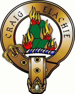
Craigellachie Crescent, Aviemore. “'Standing fast' as guard between Strathspey and Badenoch is the huge mass of Craigellachie, which gives its motto to the Clan of Grant— Stand fast: Craigellachie!” The name reads in Gaelic as Eileachaidh, which appears to be an adjective formed from the stem eilech, or older ailech, a rock, nominative ail. The idea is the stony or craggy hill—a thoroughly descriptive adjective." Badenoch: Its History, Clans, and Place Names, by Alexander Macbain, Transactions of the Gaelic Society of Inverness, volume XVI, 1889–90, page 148 at page 181. Here is a map that shows the craggy summit of Craigellachie about 500 (496) metres, on the western edge of the Craigellachie Nature Reserve, between Lochan Dubh to the southwest and Aviemore to the northwest. For a photograph from the summit, see photograph #5 at the bottom of page 40 of the Autumn 2008 issue of The Nature of Scotland. See: A Wintry Aviemore from Craigellachie and Stand Fast Craigellachie! in Scotland: Picturesque and Traditional with Staff and Knapsack by George Eyre-Todd, Glasgow 1906, chapter XVI, page 258. Railway Guide, page 48. The Clan Grant Crest to the left is the work of Tomasz Steifer. Gdansk, and may be copied or modified only in compliance with the terms of his GNU Free Documentation License (published by the Free Software Foundation) with proper attribution and "with no Invariant Sections, no Front-Cover Texts, and no Back-Cover Texts". See: What is a Copyleft? |
|
| 26.4 | 0 | Aviemore [Avemore] | Aviemore, where you enter Speyside. See: Craigellachie National Nature Reserve and Aviemore (Local Area) and Grantown and the Adjacent Country: a Guide to Strathspey by William Reid (3d edition), Grantown 1895, at pages 45–47; Aviemore, Dalfaber Road, Craigellachie on Canmore Mapping (click on View this site on a map.) See: Aviemore on the Gazetteer for Scotland. |
| 28.4 (est) | 2 | Intersection of A9 and A95 | Turn to the right off A9 to follow A95 down river along the River Spey. |
| 36.4 | 14.1 | Tomatin, at Findhorn Bridge on Main Road | A9 crosses the River Findhorn. |
| 53.9 | 31.6 | Inverness | Via A9, a shorter route to Inverness than A95. |
| 28.9 | Boat of Garten | The church of Duthil, to the north of Boat of Garten, is one of the few old Popish chapels that survived the Reformation. )See the next entry.) The tomb of the family of Grant of Grant reposes against its northern wall. One part of the enclosure is reserved for the chief and his offspring, while the outer part belongs to collateral branches, as the families of Kinchurdy, Tullochgriban, and Balladirin. See: Duthill, Old Parish Church and Churchyard (St.Peter's Chapel), which includes a map that shows the Clan Grant Centre immediately south of the church. | |
| 31.9 | Duthil (Glencarnie) | On the River Dulnain and A938, north of the Boat of Garten and west of the River Spey. The ancient lordship of the Grants, Glencarnie, is in the modern parish of Duthill. Fraser I pages xlv—xlviii (The Barony and Lordship of Glencarnie). Duncan Grant of Freuchie, in 1457, was the Crown tacksman of Ballindaloch, and may simultaneously have been the Crown tacksman of Glencarnie. Fraser I page liii.
"The lordship of Glencarnie, as distinguished from the lands so called, also included the lands of Ballindalloch. Though these lands are situated on the eastern bank of the Spey, and about twenty miles lower down the river, they are mentioned as lying in the lordship of Glencarnie, and are included m the same feudal titles. Soon after their acquisition they were bestowed upon Patrick Grant, who founded the cadet family of Grants of Ballindalloch." Fraser I page lvi. |
|
| 33.0 (est) | Tullochgorum [Tullochgoram] | See Tullochgorum Standing Stones. Also known as Tullochgorm. Less than a half a mile up (southwest) the River Spey from where the River Dulnain flows into the Spey below (northeast of) Broomhill, and below (south of) where the River Nethy flows into the Spey. Reverend James Grant, Presbyterian minister, was born in Tullochgorum. Robert Burns said that the song of Tullochgorum was "the best Scotch song that Scotland ever saw." Fraser I page lxvii. Tullochgorm was "disposed on 14th June 1491 by George, second Earl of Huntly, with consent of his eldest son, Alexander Lord Gordon to John Grant of Freuchie 'for satisfactioun and contentatioun of the landis of Fotterletter, Innerloquhies, and tua Innerrowries, lyand within the baronie of Strathdowin and sherefdome of Banff." Fraser I page lxviii. | |
| 32.8 (est) | 0 | Turn right from A95 at the mouth of the River Nethy | Head southwest on Station Road. |
| 34.5 | 1.7 | Nethy Bridge (formerly Abernethy) | About 3 1/2 miles up (southeast) of the River Nethy from its confluence with the River Spey, on B8079. See The Barony of Abernethy, Fraser I pages lxx–lxxiii. In 1516 or earlier, "John Grant, second Laird of Freuchie, obtained a grant of the lands and lordship of Abernethy in feu at a fixed annual rent of £'40 Scots." Fraser I page lxxii.
Fraser I, page lxx. The Barony of Abernethy, in the Parish of Abernethy and County of Inverness. "As its name indicates, the barony of Abernethy is situated in the district surrounding the river Nethy, in the shire of Inverness, especially at or near its confluence with the Spey, of which it is a tributary stream." |
| Lurg [Lurg] | Southeast of Lettoch and northwest of the Braes of Abernethy; on the Lurg Burn [Burn of Lurg] that flows northwest into the Dorback Burn [The Dorback], which flows into the River Nethy. | ||
| 38.9 | 5.4 | Auchernack [Achyernack] | Auchernack Burn — Auchernack Burn flows into the River Spey from the southeast and is 3.6 miles south of A9 on B8079. "Three centuries or so ago a James Grant of Auchernack left eight sons, who founded several families that have continued." Railway Guide, page 53. The Laird of Freuchie and Grant has a "pleasant summer residence" in Auchernach. Fraser I page lxxiii. |
| 34.5 | 0 | Dulnain Bridge | On the River Dulnain northwest of the River Spey and A95. |
| 6.4 | Carrbridge | West on the River Dulnain on A938, 30.0 miles from Laggan by a more direct route. | |
| 36.2 | Inverallan [Kirk of Inverellan] | Just west of Loch Anacach. See: Inverallen House.
"The lands of Inverallan were among the earliest possessions of the Grant family, and the first which they acquired in Strathspey. They were possessed in the reign of King Robert the Bruce by John le Grant, and have ever since been inherited by the Grants, with one interruption caused by the lands having been provided to co-heiresses." Fraser I page xxix. "The stream which flows down from Tobair-Alline, where it takes its rise, through Glenbeg, and which from that circumstance is now called the Glenbeg Burn, evidently, in earlier days, bore the name of the Allan, and gave the designation of Inverallan to the district which surrounds the lower part of its course. At its confluence with the Spey there appears to have been, in former days, a strong fort, whence, probably, the earlier Lords of Inverallan bore sway over their little territory, and dispensed feudal justice to their dependants." Fraser I page xxxiv. On June 26, 1587, John Grant, fifth Laird of Freuchie, settled a dispute over the ownership by purchasing the lands of Inverallan, Glenbeg, Gaich, Craggan, and Dreggie, from William Hay of Main. Inverallen was included in the newly formed Barony of Cromdale. Fraser, I page xxxii. |
|
| 37.3 | Grantown-on-Spey [Grantown] | Built in the 18th century by Sir James Grant. Castle Grant (formerly Freuchie Castle — Fraser I page xl; and before that, Ballachastell), ancient residence of the chief of the Grants, is less than 2 miles northeast of the town. See Find A Grave for a few of these Grants. Railway Guide, page 50. See: The Barony of Freuchie, Fraser I pages xxxv—xliv. See also Fraser I page xci.
The first Lord of Freuchie was Sir Duncan Grant, who ruled from 1434 to 1485. The second was John "Bard" Grant who ruled from 1485 to 1528. Clan Grant — The Chiefs of Grant: A Complete List. "Freuchie continued to form a distinct barony and the principal possession of the Grant family until 1694, when Ludovick Grant obtained the Crown charter erecting all his lands into the Regality of Grant, and the barony of Freuchie was absorbed in it." Fraser I page xxxix. "As the principal residence of the family of Grant, Castle Grant has been cherished and venerated not only by the members of the family, but by all the name of Grant, as the home of their chief." Fraser I page xl. "The present town of Grantown, however, is of more modern date [than the previous village], having been projected in 1765 by Sir Ludovick Grant of Grant and his son, the good Sir James. The site of this town was formerly a barren heath moor called Feavoit. Plans and leases were prepared, and by 17G6 the first houses were erected. " Fraser I page xci. |
|
| 38.6 | Congash | ||
| Tornabirrack | Tomaberrack. Near Feabuie and the River Spey east of Grantown-on-Spey and near Congash. | ||
| 40.2 | Cromdale [Cromdall] | Railway Guide, page 47. See The Barony of Cromdale, Fraser I, pages lxxiv–lxxviii. Sir Ludovich Grant took measures to insure that no family other than a Grant would obtain a footing within upper and lower Craigellachie.
"Sir Ludovick's ancestors were of the same mind, and especially so with regard to the district now known as the parish of Cromdale. That was their home, and being so, it in course of time entirely fell into the possession of the family of Grant. The previous owners of the old barony of Cromdale, the Nairns, alienated a portion of it to the Laird of Freuchie, and a century later the entire barony was made over to the Grants." Fraser I page lxxiv. |
|
| 44.6 | Dalvey [Dalvey] | Mileage is to the Burn of Dalvey at a point 0.9 miles south of A95. Mains of Dalvey are on the west side of the Burn of Dalvey where it flows from the south into the River Spey. Near the Albert Memorial Hall Station. Turn right of A95 onto Balmenach Road. | |
| 46.2 | Advie | Advie. John Grant was minister of the parish of Advie from 1861 to 1869. Neil Grant and Patrick Grant were ministers from 1588 to about 1590 and 1590 to 1624. Memorials in Advie Cemetery mentions 37 Grants. See: Grant — Cromdale and Inverallan and Advie on Genealogy.com. | |
| 51.2 | Ballindalloch Castle [Ballindaloch] | Ballindalloch Castle. Known as the Pearl of the North, where the River Avon flows into the River Spey. | |
| 51.2 | Inveraven Church [Kirk of Inverawn] | See: Parish of Inveraven in The New Statistical Account of Scotland: Banff. Elgin, Nairn, Edinburgh and London 1845, volume XIII, pages 123–143 (written in 1836). | |
| 57.6 | Knockando [Knockendon] | Knockando. Cnoc Cheannachd in Gaelic. Around 1650, Gaelic speaking priests were called for in Morayshire places like Cnoc Cheannachd because a substantial proportion spoke only Gaidhlig. | |
| 57.7 | Wester Elchies [Wr Elchies] | Mileage is to Elchies Road. Wester Elchies is on the west side of the River Spey opposite and above Aberlour. Here is a map.
"Wester Elchies, with its mill, fishings on the Spey, porter's croft and ferry coble; Kinchirdie, with its fishings and pertinents, and the lands of Canon, were feu-farmed to John Grant of Culcabock." in 1544. Fraser I page lxv. "When Baron Grant had determined to sell his estate of Easter Elchies in 1758, Sir Ludovick Grant could not rest in the thought that any other than a Grant should 'have a foottinng within the two Craigelachies.'" Fraser I page lxxiv. The mansion of Wester Elchies was built in 1681. Wester Elchies belonged to the Grants of Carron until 1783, when it was purchased by Robert Grant. The additions were built for James Grant (1788 - 1865) 3rd laird. |
|
| 58.1 | Aberlour [Aberlour] | Site of MacPherson-Grant Mausoleum. The town of Charleston of Aberlour was founded by Charles Grant of Elchies in 1812 — with the name of Charlestown of Aberlour after his son Charles. See: Talk on Aberlour Prepared by Dr. SB.M. Sellar. "Mr. Charles Grant was one of the best known of all the long race of schoolmasters. He was affectionately known as "schooley Grant" — born in Strondhu, Knockando 1807. He started in Aberlour in 1844 and taught, much of the time single handed, for the next 30 years. (Logbook 1874 - 87 pupils, 1 principle teacher - C. Grant) | |
| 59.8 | Craigellachie (Lower) [Craig Elchie]
|
Craigellachie. Here is a picture of Craigellachie from the River Spey. See Craigellachie on the Gazetteer for Scotland.
Under the heading of The Two Cragellachies, The Chiefs of Grant by William Fraser, Edinburgh 1883, volume 1, at page xxi of the Introduction, discusses the upper Craigellachie in the Badenoch, and the lower Craigellachie in Moray: "When, about the middle of last century, Baron Grant of Elchies proposed to sell his estate in Strathspey, Sir Ludovick Grant was anxious to secure it, either for himself or one of the clan. In a letter to his law-agent he wrote that he wished to preserve all the lands lying between the two Craigellachies in the name of Grant. These two rocky eminences are conspicuous objects in Strathspey. The upper or western Craigellachie forms the dividing boundary between Badenoch and Strathspey, and was the rendezvous for the Grant clan in time of war. The lower Craigellachie stands at the confluence of the Fiddich with the Spey, and forms the point of contact of the four parishes of Aberlour, Knockando, Rothes, and Boharm. The upper Craigellachie is generally supposed to have furnished the crest of the Grant family, which is a mountain in flames. When the chief wished the clan to assemble, fires were kindled on both Craigellachies, hence the name, 'Bock of alarm.' The war-cry of the clan was Stand Fast, Craigellachie, and their armorial motto is the same. To the left is a badge from The Symbols of Clan Grant on the website of The Clan Grant Society US. |
|
| 3.2 | Arndilly | South of Craigellachie down the River Spey. | |
| 6.4 | Orton (at Boat O'Brig) | North by northwest, by way of B9015 and A941. Grants owned land at Orton adjoining lands of Elie and Inchberry on the west side of the River Spey. Cassillis, page 534. | |
| 6.5 | Mulben | West of Keith on A95. | |
| Meikle Balnabreich | West by southwest of Keith on A95 and A96 toward Craigellachie. See: Castle Balnabreich | ||
| 11.9 | Keith | In the Isla valley, 8.1 miles southeast of Fochabers. | |
| 13.7 | Forgie | Northwest of Keith on A96 — about half way to Elgin. | |
| 18.0 | Fochabers [Fockabers] | From Craigellachie through Keith. Fochabers — on the east side of the River Spey, less than a half a mile southwest of Gordon Castle, originally called the castle of the Beg of Gight; 4.1 miles south of Spey Bay on the Firth of Moray; the principal seat of the Dukes of Gordon dating back to the 1400s. | |
| 27.0 | Elgin | From Craigellachie through Keith. On the south coast of the Moray Firth, near the mouth of the River Lossie (Lossiemouth). Elgin is 39.1 miles east by northeast of Inverness, 9.1 miles west by northwest of Fochabers, and 65.6 miles northwest of Aberdeen — through Fochabers and Keith. | |
| 39.2 | Forres | From Craigellachie through Keith. Dalvey House is on Muckle Burn west of Forres — across the Findhorn River, and was known as Grangehill until c.1740. It was built for Sir Alex. Grant c.1750 in Georgian Style, with a tent wing added c.1850. "Long a separate property belonging to the family of Ballindalloch, who sold it to James Grant of Gartenbeg. In 1688 he was created a baronet. He died without issue, and the property ultimately fell into the hand of the Laird of Grant." Railway Guide, page 47. | |
| 61.5 | The Macallan Distillers | On the west side of the River Spey at Charlestown of Aberlour about 1/2 miles south of Easterelchies Wood. The Macallan Distillers website give a brief history of the Easter Elchies, beginning with a grant in 1543 to Duncan Grant of the lands of Easter Ellochy by the Bishop of Moray. | |
| 61.6 | Easter Elchies [Elchie] | Easter Elchies and Wester Elchie on the west side of the River Spey are ancestral homes of the Grants. Railway Guide, page 39. Easterelchies Wood is on the western edge of the River Spey on B9102 immediately west of and across the river from lower Craigelachie.
"Wester Elchies, with its mill, fishings on the Spey, porter's croft and ferry coble; Kinchirdie, with its fishings and pertinents, and the lands of Carron, were feu-farmed to John Grant of Culcabock" in 1544. Fraser I page lxv. |
Roy Military Survey of Scotland, 1747–55, calls the River Avon the River Awn.
| Miles | Spur | Name of Place | Comments |
| 0 | Ballindalloch Castle [Ballindalloch] | Contains a mausoleum built for General James Grant in 1807. | |
| 3.6 | Craggan [Craggan] | See: The Craggan, Free Church. | |
| Downan Wood | |||
| Downan Bridge (Bridgend of Livet) | Where B9136 meets B9008. Downan Bridge carries B9136 across the River Livet just above the confluence of the River Livet and River Avon. Downan is a short distance to the Northwest of the Bridge, across the river from the remains of Drumin Castle. | ||
| 5.1 | Drumin [Drummin] | Site of the remains of Drumin Castle. | |
| 7.2 | Dell Farm [Dell] | ||
| Mains of Inverourie | On the west side of the River Avon. near where the Alt Ben na beinne flows into the Avon from the west and the Chabat Water from the south. North of the Tomintoul Glenlivet Distillery. | ||
| Inverlochy [Inverlochie] | See: Inverlochy Spearhead (Bronze). On the west side of the River Avon. Where the Burn Lochy enters the Avon from the southwest. Here is a photograph taken near Inverlochy of grazing land in Strath Avon looking west toward the Hills of Cromdale. | ||
| Kirkmichael Parish Church | St Michael's Cross. On the east side of the Avon, southeast and across the river from Inverlochy; about 1 1/2 mile south of where the Burn of Lochy enters the River Avon from the southeast, and about 1 mile north of where the Conglass Water enters the River Avon from the southeast. Here is a photograph of St. Michael's Church, Strath Avon. See: Parish of Kirkmichael in The New Statistical Account of Scotland: Banff. Elgin, Nairn, Edinburgh and London 1845, volume XIII, pages 296–392 (written in 1842). | ||
| 11.5 | Tomachlaggan [Tomachlagan] |
See: Tomachlaggan Farmstead. | |
| Croughly | On the eastern side of the Conglass Water to the southeast of Tomachlaggan. About 2 miles north of Tomintoul. Home of the Gordons of Croughly. See: Croughly, Garden Walls and Gatepiers, Kirkmichael. | ||
| Easter Fodderletter [Fotherlett Tomintouler] | On the west side of the River Avon. “Easter” and “Wester” are commonly used in place names in Scotland but have no relation to the compass bearings. Easter means downstream and wester upstream. | ||
| Wester Fodderletter [W. Fotherletter] | On the west side of the River Avon. | ||
| 14.9 | 0 | Tomintoul [Tomintoul] | Tomintoul. Highest village in the Highlands at 1164 feet. (See:Tomintoul and Glenlivet.) On B9136, which follows the River Avon. |
| [Achriachan] | Just west of Tomintoul on the Conglass Water. [Water of Connalash] | ||
| 14.1 | Grantown-on-Spey | Grantown-on-Spey is 14.1 miles to the northwest of Tomintoul on A939. | |
| 16.6 | Delnabo [Delnambo] |
On the west side of the River Avon just south of Tomintoul where the Water of Ailnack [The Caploch] enters the Avon from the southwest. "Delnabo Lodge is an eighteenth-century house with nineteenth-century additions in Scots Baronial style. ... There may have been been a house on this site since the medieval period, originally held by members of the Grant family, from their feudal superiors, the Gordons. It remained in the hands of the Grants until November 1891, when it passed to Colonel John George Smith, who was then the proprietor of Glenlivet Distillery." (Text prepared by RCAHMS as part of Accessing Scotland's Past. ) | |
| 17.1 | Delavorar [Dalvorrar] | Spelled Dalvorir and Dalvorar in document 337 of Frazer III, part 2, pages 419–421. See Auchnahyle in the second row below. | |
| Easter Gaulrig [E. Gaularig] | On the west side of the River Avon. | ||
| 20.6 (est) | Auchnahyle | On the east side of the River Avon across from Easter Gaulrig, just northeast of waterfalls on the Muckle Fergie Burn shortly before it enters the River Avon from the east. Google maps shows the driving distance from Delnabo to Muckle Fergie Burn as 3.5 miles. Spelled Auchnahayll and described as a pendicle of the lands of Dalvorir, also spelled Dalvorar, in the "assignation, in form of Contract, between John Grant of Freuchy and Alexander Gordoun, elder of of Strauthoune" dated March 24, 1612. Frazer III, part 2, pages 419–421, document #337. | |
| Wester Gaulrig [W. Gaularig] | On the west side of the River Avon. |
For a sketch map showing the relative positions of Dufftown, Glenlivet, Tomintoul and Ballindalloch, and the Rivers Spey, Avon and Livet, go to The Speyside Way on Moray Ways. For orientation to the major geographic references on this page, go to Google Maps and ask for directions between points listed below with the road mileage between them:
Edinburgh to Glenlivet: 158 miles.
Glenlivet to Dufftown: 13.3 miles northeast.
Here is an excerpt from Parish of Inveraven in The New Statistical Account of Scotland: Banff. Elgin, Nairn, Edinburgh and London 1845, volume XIII, page 132 (written in 1836).
About 200 years ago, the Grants were proprietors of Blairfindy; the Stewarts, of Drumin and Kilmaichlie; and a family of the name of Nairn, of Moranges, — while a different branch of the Grants, commonly called the Craig-Achrochcan Grants, held Ballindalloch.
| Miles | Spur | Name of Place | Comments | |
| 0 | Drumin, Moray [Drummin] | Drumin Castle is shown in the northwest corner of The Crown Estate Walking Map. See also: Drumin Farm, Historical Residence of the Duke of Gordon's Factor. See: Drumin Castle and Drumin on Canmore, and Drumin Castle on the website of Cairngorms National Park. | ||
| 1.5 | Glenlivet [Aldnacash] [Wr Drummins] | On the west side of the River Livet, just south of where the River Livet flows into the River Avon. (See: The Glenlivet Estate.) | ||
| 1.6 (est) | Blairfindy Castle | Completed by John Gordon in 1564; in ruins since 1746. | ||
| 1.7 | Castleton of Blairfindy | |||
| 2.1 | Blairfindy Farm [Blairfindy C.]
|
|
||
| 3.2 | Shenval | Turn left off B9008 about 2.4 miles southeast of Drummin, and travel about .8 miles northeast on B9009 toward Dufftown, which is 13.3 miles from Drumin, and 10.1 miles from Shenval. The stream, Allt a' Choileachain, enters the Burn of Tervie at Shenval. The Battle of Glenlivet in 1594 was fought nearby. See: An Old Story of a Highland Parish in the Scalan Archive. | ||
| Tombreckachie [Tombreackachie] | On the east side of the River Livet where the Burn of Tervie [Water of Tarvie] enters the River Livet from the east. | |||
| 2.5 | Auchbreck [Auchbreack] | The site of the Glenlivet Parish Church — built in 1826. | ||
| Auchoracan [Achoracan] | On the east side of the River Livet, just north of where the Burn of Nevie enters the River Livet from the east. | |||
| 3.1 | Nevie Farm [Nevie] [Little Nevie] | There was a Chapel of Christ and Burial Ground on the south side of the Burn of Nevie where it entered the River Livet from the east. The site was washed away by a flood, probably on August 3 and 4, 1829. By 1869, no trace of any building could be found. Here is a quotation from The Great Floods of August 1829 in the Province of Moray and Adjoining Districts by Sir Thomas Dick Lauder, Elgin 1873 (3d edition), pages 125–6:
"The River Livet was very destructive. It rose at the bridge of Nevie twelve feet above its ordinary level. It was towards evening that it came down, in a few minutes, and broke directly through the middle of the house of John Grant, shoemaker, through the middle of the house of John Grant, shoemaker, above the bridge, on the right bank, sweeping the centre of it entirely out, and leaving the ends; after which it assailed the arch, of forty-six feet span, and tore down the upper part of it." |
||
| 4.0 | Tomnavoulin [Tamunlan] | The distance from Tomintoul to Tomnavoulin on B9008 to the southwest is 6.4 miles. | ||
| 4.5 | Tombae — Roman Catholic Church of the Incarnation [Tambea] | The street view on Google maps shows the church and cemetery. At Tombae, the River Livet turns east, while this table follows B9008 to the southwest to join the Conglass Water and the River Avon at Tomintoul. "In Glenlivet, where about three-fifths of the people are of the Roman Catholic persuasion, there are two Roman Catholic chapels, — the one at Tombia, pretty far up the glen, — the other at Chapelton, in the Braes of Glenlivet. The former is a large building capable of containing from 800 to 1000 persons, — but only partly finished: the latter contains about 300." See: Tombae Church Closes. |
||
| 4.7 | Croftbain [Croftbane] | |||
| 5.6 | 0 | Knockandhu | See the Map of Braes of Glenlivet on Gazetteer for Scotland. | |
| Clashnoir | See: NJ2222—Clashnoir from Buiternach. See Pictures of Clashnoir, and United Kingdom/Scotland/Clashnoir on flickriver. |
|||
| 3 | Eskemore. | Turn to the east at Knockandhu and join Crombie Water in the Braes of Glenlivet; follow Crombie Water to the south east. Eskemore. | ||
| 8.7 | 4 | Chapeltown (Chapeltown of Glenlivet) | Our Lady of Perpetual Succour, Braes of Glenlivet. | |
| 4.4 | Eskemulloch | The car park for the Scalan Heritage Trail. | ||
| 9.7 | 5 | Scalan [Scalen] | Roman Catholic Seminary. Hidden College of Scalan. See also: Braes of Glenlivet, Scalan, Cottage and Scalan Roman Catholic College. | |
| Glenbuchat (across the Ladder Hills) | At the right edge of the Map of Braes of Glenlivet on Gazetteer for Scotland. East — across the Ladder Hills from Scalan (by a foot path from Blye Water at Ladderfoot, which is just east of Demickmore and northeast of Scalan, and down the Water of Buchat from the Glenbuchat Shooting Lodge at Badenyon to the Mains of Glenbuchat and Glenbuchat Castle, which is now in ruins. For a map of The Ladder Path between Scalan and the Kirkton of Glenbuchat, go to the end of the Scalan News No. 26 of May 2003. The Ladder Path across the Ladder Hills from from the College of Scalan to the Lenbuchat Huntin Lodge stretches about 6 miles. Here is a map that shows the distance from the College of Scalan to Glenbuchat as the width of 9 squares, from #24 to #33. This is 9 kilometers on a straight line, or slightly over 5 1/2 miles. Three low marker cairns near the Ladder Path mark the boundary between the counties of Banffshire and Aberdeenshire. There is an old boundary marker on Dun Muir. By road through Tomintoul, the distance from Scalan to Glenbuchat Castle is 29.7 miles. The road extends another 3.2 miles to the northwest to Badenyon, where The Ladder Path to Scalan begins. Here is information on a nearby walk along Glenbuchat Ridge, with a map. See The Michies of Badenyon by George Watt in the Glenbuchat Heritage Archive. | |||
| Achdregnie | In the Braes of Glenlivet to the east by northeast of Knockandhu and on the north side of the River Livet and less than a kilometer to the north of Inverblye — at the end of the road from Tombae to the northwest. | |||
| 6.3 | Auchnarrow | |||
| Inchnacape | ||||
| Conglass Bridge | "In 1794, the Duke of Gordon had a road built from Glenrinnes to Tomintoul, allowing carriages and other wheeled vehicles to travel the length of his estate. Bridges were built at several points along the route, including this one which spans the Conglass Water near Tomintoul." | |||
| 10.4 | Tomintoul | Tomintoul. Highest village in the Highlands at 1164 feet. (See: Tomintoul and Glenlivet.) The distance of 10.4 miles is on B9008 that starts along the River Livet. The distance of B9136, which follows the River Avon, is 9.8 miles. See: Tomintoul, St Michael's Roman Catholic Chapel, Burial Ground. |
| Miles | Spur | Name of Place | Comments |
| 0 | Craigellachie (lower) | ||
| 4.5 | Balvenie Castle | ||
| 4.9 | 0 | Dufftown | |
| 1.3 | Tullochallum | Tullochallum Cottages are 1.3 miles southeast of Dufftown on A941. | |
| 2.3 | Milltown of Auchindoun | Northeast of Tullochallum Cottages on A920 | |
| Auchindoun Castle | Auchindoun Castle is high on a hill overlooking the Fiddich valley. On the west side of the River Fiddich as it flow to the southwest—just south of Upper Keithac. "Present castle built c. 1479; the Gordons received the lands in 1535." See: Castles of Clan Gordon Wiki—Auchindoun; Auchindoun Castle, Dufftown (Aberdeenshire) and Auchindoun Castle, near Dufftown. For a large collection of photographs, see Auchindoun Castle on Canmore. | ||
| 15.6 | Cabrach | See: Cabrach Parish Church, Burial Ground (near Kirktown) and Lower Cabrach Church and Manse (United Free Church Manse, Bridgend, Cabrach). In 1705 the Synod of Aberdeen recognized the parish of A'Chabrach as Gaidhlig (Gaelic) speaking. On the River Deveron. |
Fraser I, pages lxxix–lxxxii. The Barony and Castle of Urquhart, in the Parish of Urquhart and Glenmoriston Invernesshire.
"The barony or lordship of Urquhart, which lies about eight or ten miles south-west of Inverness, and on the west side of Loch Ness, is of considerable extent, measuring from east to west eighteen miles, and from north to south twelve. It forms the outlying province of the Grant possessions, being entirely separated by intervening estates from the lands in Strathspey, but notwithstanding its remote position, this barony has been faithfully retained by the Lairds of Grant since their acquisition of it in the year 1509. ...
"For the purpose of securing good government and a settled condition of affairs among the inhabitants, and for reducing the refractory and disobedient to a dutiful allegiance, King James the Fourth, on 8th December 1509, granted feu-charters of these lands to John Grant, second Laird of Freuchie, and two of his sons. The Laird himself received the lands of Urquhart, all united and erected into one barony, to be called the Barony of Urquhart, with the castle of Urquhart as the principal messuage. The office of forester of the royal forest of Cluny was included in the grant, but by a special exception the forest itself was to continue the property of the king. ...
"On similar conditions were granted to John Grant, youngest son of the Laird of Freuchie, the lands of Corriemony, all united and erected into one barony, to be called the Barony of Corriemony. ...
"The other son, to whom were given the lands of Glenmoriston, was John Grant, an illegitimate son of the Laird of Freuchie, and designated "Mor," to distinguish him from his brother of the same name, who received Corriemony. He also held the lands of Culcabock, and appears to have been a man of unusual stature or bulk, as, in one document of the time, he is styled "Meikle John Grant of Culcabock." He obtained the lands of Glenmoriston, Conachan, Craskie, Inach, Auclilayn, Tullechard, Dundreggan, Innerwick, Blairy, Inver, Coulnakirk, and Meikle Cluny, all erected into a barony, to be called the Barony of Glenmoriston."
For maps, see jump in to Loch Ness and jump in to Moriston and Affric... on www.visitlochness.com.
| Miles | Spur | Name of Place | Comments |
| 0 | Fort Augustus | Here is a map of South Loch Ness. | |
| 6.3 | 0 | Glenmoriston Post Office | At the intersection of A82 and A877. |
| 7.7 | 1.4 | Levishie | On the River Moriston northwest of Invermoriston. |
| 12.5 | 6.2 | Dundreggan | On the River Moriston. Dundreggan is shown as a settlement on the Map of the Parish of Urquhart and Glenmoriston in the Historical County of Inverness |
| Inverwick | Southwest of and across the River Moriston from Dundreggan. | ||
| 14.3 | 8.5 | Glen Moriston Glenmoriston | Maps show Glen Moriston east of Loch Cluani (and Dundreggan Dam at its east end), on A887, mostly on the north side of the River Moriston, centered around the village of Dalreichart and including the village of Dundreggan to the east. Canmore reports this about An Abait, Dalchreichart: "The great sanctuary in the parish was at An Abait - The Abbey - lying between Ballintombuy (NH 2813) and Dulchriechard (2912) in Glenmoriston. ... The district was probably the 'Kirk Lands' of Glenmoriston, mentioned in 1572." The Kirk Lands were subsequently appropriated by the Lairds of Glenmoriston. Urquhart and Glenmoriston: Olden Times in a Highland Parish, by William MacKay (Second Edition) Inverness 1914, page 117 (footnote).
See Appendix VIII, Grants of Glenmoriston, in Urquhart and Glenmoriston: Olden Times in a Highland Parish by William MacKay, Inverness 1914, page 510. "The other son, to whom were given the lands of Glenmoriston, was John Grant, an illegitimate son of the Laird of Freuchie, and designated 'Mor,' to distinguish him from his brother of the same name, who received Corriemony. He also held the lands of Culcabock, and appears to have been a man of unusual stature or bulk, as, in one document of the time, he is styled 'Meikle John Grant of Culcabock.'" See Urquhart and Glenmoriston: Olden Times in a Highland Parish, by William MacKay, Inverness 1893. "About eleven miles beyond Urquhart Castle, on the same side of Loch Ness, is the opening of Glenmoriston, through which the river Moriston descends by a fine fall into the Loch, and at its mouth stands the square tower of Invermoriston House, well known in the first half of this century for its Highland hospitality. In these days, many questions arise as to the owner— ship of land, in whom it is ultimately vested. King James IV had no doubt at all on the subject, for, in the year 1509, he bestowed the whole of Glen Urquhart and Glenmoriston, with all the space between, on John Grant of Freuchie and his two sons. This splendid gift, amounting to about a hundred and fifty square miles, was divided into three baronies, Urquhart, Corrimony and Glenmoriston. The first was assigned to the chief, the second to his second son John, and the third to an illegitimate son of his, also named John. From these two sons sprang three branches of the family: Corrimony, Shewglie and Glenmoriston ..." See The Genealogist edited by Walford D. Selby, volume I, London, 1884, pages 214–224 — The Chiefs of Grant by Canon A. R. Grant, at page 217.d |
| Dalreichart | Shown as a settlement on the Map of the Parish of Urquhart and Glenmoriston in the Historical County of Inverness on the Gazetteer for Scotland. | ||
| Balintombuie | Just west of Dalreichart on the north side of the River Moriston. | ||
| Achlain House | Achlein. On the River Moriston, southwest of and across the river from Dalreichart. Achlain is shown as a settlement on the Map of the Parish of Urquhart and Glenmoriston in the Historical County of Inverness. | ||
| Balnacarn | Balnacarn is shown as a settlement on the Map of the Parish of Urquhart and Glenmoriston in the Historical County of Inverness. | ||
| 18.0 | 11.7 | Tomchrasky is shown as a settlement on the Map of the Parish of Urquhart and Glenmoriston in the Historical County of Inverness | |
| Craskie | West of Dundreggan along the River Moriston. | ||
| 21.6 | 15.3 | Bun Loyne | Site of the Glen Moriston Suspension Bridge across the River Loyne — on the south side of the River Moriston, and on the west side of the River Loyne where it enters the River Moriston from the south. Where A87 intersects A887. 28.5 miles by way of A87. |
| Loch Cluanie Dam | At the east end of Loch Cluanie. | ||
| 27.1 | 20.9 | Loch Cluanie | Distance is by way of A887 that runs along the River Moriston. |
| 30.5 | 24.2 | Cluanie Inn | At the mouth of the Cluanie River as it flows into the west end of Loch Cluanie. |
| 7.0 | Invermoriston | Just northwest of where the River Moriston flows into Loch Ness from the southwest. | |
| Achnaconeran | Achnaconeran is shown as a settlement on the Map of the Parish of Urquhart and Glenmoriston in the Historical County of Inverness | ||
| Balneg | Balneg is shown as a settlement on the Map of the Parish of Urquhart and Glenmoriston in the Historical County of Inverness | ||
| 16.9 | Urquhart Castle [Castle Urquhart] | "The barony or lordship of Urquhart, which lies about eight or ten miles south-west of Inverness, and on the west side of Loch Ness, is of considerable extent, measuring from east to west eighteen miles, and from north to south twelve. It forms the outlying province of the Grant possessions, being entirely separated by intervening estates from the lands in Strathspey, but notwithstanding its remote position, this barony has been faithfully retained by the Lairds of Grant since their acquisition of it in the year 1509. ... "For the purpose of securing good government and a settled condition of affairs among the inhabitants, and for reducing the refractory and disobedient to a dutiful allegiance, King James the Fourth, on 8th December 1509, granted feu-charters of these lands to John Grant, second Laird of Freuchie, and two of his sons. The Laird himself received the lands of Urquhart, all united and erected into one barony, to be called the Barony of Urquhart, with the castle of Urquhart as the principal messuage." Fraser I page lxxix (The Barony and Castle of Urquhart). | |
| 18.4 | Lewiston | On the River Coiltie just before it flows from the southwest into the River Enrick at Loch Ness. Fraser I, page lxxxi. "Brigadier Alexander Grant had it in view to build a town on a beautifully situated moor between Balmacaan and the church of Urquhart, but it was left to Sir James Grant, commonly called 'the good Sir James,' to execute this purpose, which he did about the year 1767. The town was to be named Lewistown or Kilmore, and Sir James intended that it should consist of one great street about sixty feet wide, and several smaller streets about twenty-four or thirty feet in width. Manufacturers and artisans were to be invited to settle, the harbour was to be rendered commodious and safe, good roads were to be constructed and maintained to facilitate communication, and a weekly market was to be held, with fairs at appointed times." | |
| 18.6 | Glenurquhart [Glen Urquhart] | Loch Meikle is in Glen Urquhart. The River Enrick flows east from Loch Meikle to to Loch Ness. | |
| 18.6 | Balmacaan House | Distance is to Balmacaan Road. West of Lewiston, south of the River Enrick. Seat of the Earls of Seafield on the Glen Urquhart Estate. | |
| 18.8 | 0 | Drumnadrochit | Up the River Enrick. |
| Auchtemerack | About a half mile northwest of and across the River Enrick from Drumnadrochit. | ||
| 23.4 | 4.6 | Balnain | Up the River Enrick after it flows out of Loch Meiklie. Balnain is shown as a settlement on the Map of the Parish of Urquhart and Glenmoriston in the Historical County of Inverness |
| 4.4 | Loch Meiklie | ||
| Lochletter | On the southeast of Loch Meiklie near where the River Enrick enters the lake. | ||
| 25.6 | 6.8 | Shewglie | On the River Enrick above Loch Meiklie. See Appendix VII Grants of Shewglie, in Urquhart and Glemoriston: Olden Times in a Highland Parish by William MacKay, Inverness 1914, page 509. "Grant, James (1750–1808), East India Company servant and author, was born on 30 May 1750 at Shewglie, Glen Urquhart, Inverness-shire, the son of the laird of Shewglie. In 1768 he gained, via his uncle Alexander Grant, an appointment in Bengal with the East India Company. See The Genealogist edited by Walford D. Selby, volume I, London, 1884, pages 214–224 — The Chiefs of Grant by Canon A. R. Grant (probably Rev. Alexander Ronald Grant, Canon of Ely and Rector of Hitcham, Suffolk, son of Patrick Grant of Rescastle, 8th Laid of Shewglie). See also: The Life of Charles Grant, sometime member of parliament for Inverness-shire and director of the East India Company, by Henry Morris, London 1904. Charles Grant (1746–1823) was descended from the Shewglie line of Grants. He was the son of Alexander Grant (c.1713 –1762), who was born at Shewglie, married Margaret MacBean about 1743, and who was severely wounded at the Battle of Culloden. Charles Grant was born at the farm house of Aldourie on April 16, 1746, the day of the battle of Culloden and named after Prince Charles Edward Stuart. See: The Northern Highlands in the Nineteenth Century — The Anglo-Indian Grants — Charles Grant on Electric Scotland. |
| 26.1 | 7.4 | Shenval | On the River Enrick. |
| 27.5 | 7.9 | Corrimony | 8.5 miles west on A 831, up the River Enrick, from A82. A831 ends at Corrimony. In the preface to his book, Urquhart and Glemoriston: Olden Times in a Highland Parish, Inverness 1914, page vi, William MacKay refers to "the learned James Grant of Corrimony." See Appendix VI Grants of Corrimony, in Urquhart and Glemoriston: Olden Times in a Highland Parish by William MacKay, Inverness 1914, page 508. Corrimony is shown as a settlement on the Map of the Parish of Urquhart and Glenmoriston in the Historical County of Inverness. |
| 33.5 | Inverness |
Fraser I, pages xxii–xxiv. The Barony of Stratherrick, in Inverness. The Original Country of the Grants.
"The earliest known territorial designation which was hereditary in the family of Grant was that of Lord of Stratherrick. ...
"Stratherrick, also called Strathfarigag, from the river which drains the more northerly portion of the valley, is a wide elevated district in the parish of Boleskine and Abertarf, and county of Inverness. It stretches along the south-eastern shore of Loch Ness, parallel with, but separated from it by a narrow ridge of hilly country which screens the valley from the loch. The Strath is watered towards the south by another stream called the Fechlin, which, issuing from Loch Killin, unites in Stratherrick with some other considerable waters, and then changes its name to the River Foyers. It is upon this river that the far-famed and often described Fall of Foyers is situated, just where the water turns to pierce the rocky ridge and seek rest in the bosom of Loch Ness.
"The lands and barony of Stratherrick, so far as can be traced, have been inherited by three families successively, the Bysets, the Grants, and their present possessors the Frasers. The Bysets are known to have held the territory from about the year 1242' a century later it was in the possession of the Grants, and appears to have passed from them before 1420 to the family of Fraser of Lovat." ...
"Although the Grants parted with Stratherrick in 1419, and thus for a time severed their connection with Loch Ness, they reappeared a century later on its opposite shore as the owners of the large district of Urquhart and Glenmoriston. Meanwhile the family had fixed their abode in Strathspey ..." (page xxviii).
For a map, see: jump in to Stratherrick on www.visitlochness.com.
| Miles | Spur | Name of Place | Comments |
| 0 | Fort Augustus [Fort Augustus] | Here is a map of South Loch Ness. See: Fort William - Fort Augustus - Inverness Military Road Re-Alignment. | |
| Stratherrick [Strath Errick] | "Stratherrick, an upland level, separated from the south-eastern shore of Loch Ness, Inverness-shire, by a narrow range of hills running parallel to the loch, to which it sends, through this range, two rivulets, the Foyers and Farigag. Possessing a variety of arable meadow, and moor land, it has a Free church, a Roman Catholic chapel, and a public school." Ordnance Gazetteer of Scotland, page 409. Here is a map. See: Gazetteer of Scotland.The 1st Grant Lord of Stratherrick (after Bisset forfeiture) was Gregory Grant, who ruled from 1215 to 1349. The second was Sir Lawrence Grant who rule from 1249 to 1275. See: The Chiefs of Grant: A Complete List. Google maps lists the Catholic Church of the Immaculate Conception in Stratherrick, at the intersection of B852 and B862, south of Loch Mhor, near where the River Gourag flows into the River Foyers, between the villages of Whitebridge and Glebe. See the Map of Stratherrick on Gazetteer for Scotland. | ||
| 9.3 | River Foyers | The River Foyers is also known as the River Fechlin. It flows from Loch Killin [Loch Killyne] 9 miles north northwest to Loch Ness. The Roy Military Survey of Scotland, 1747–1755, shows it both as River Feachlan and Water of Feachlan. The falls of Foyer are called Fall of Foirs. | |
| 9.3 | Whitebridge | The new bridge carries A862 over the River Foyers. The old bridge, built in 1732 and known as Whitebridge, now carries only pedestrians. | |
| 10.7 | Loch Knockie[Loch Knackie] | ||
| 12.7 | Lochgarthside | Loch Mhor was previously known as Loch Garth. | |
| 14.4 | Foyers | See: Walks & History with Gordon Wilson — Foyers. "After the Mormaers of Moray (whose family gave King MacBeth to Scotland) had been subdued for a while in the 13th century, the Grants had large estates in the Foyers and Stratherrick districts. Gradually the Grants’ influence and possessions in Foyers dwindled whence they migrated to Glen Moriston and Strathspey and in 1420, the Frasers acquired their first lands in Stratherrick by marriage with a daughter of Patrick Le Grant." | |
| 15.0 | Gorthleck [Gorthick] | Roy's Military Survey shows Gorthack to the west of a short waterway connecting Loch Garth to Loch Farlane. The Loch More Dam raised the water level so as to combine the two lakes. | |
| 16.1 | Errogie [Erogie] | On the north end Loch Mhor [Loch Garth] shown by the Roy Military Survey as just north of Loch Farlane. | |
| 15.7 | Inverfarigaig [Inverfarragag] | Where the River Farigaig [Farragag] enters the Loch after flowing northeast from Loch Ruthven | |
| 20.1 | Abersky | On the River Farigaig. just southwest of Loch Ruthven. | |
| 23.8 | Loch Ruthven [Loch Ruthven] | Loch Ruthven | |
| 32.1 | Inverness [Inverness] |
| Territories of Clan Grant in Scotland <http://www.magoo.com/hugh/grant2.html> Updated October 21, 2014 |
![[Link to www.VanGoghGallery.com]](/images/potatoesred.jpg) |
Feedback
» Site Search & Directory » © 1999–2014 Hugh McGough » |